Mostrando postagens com marcador English. Mostrar todas as postagens

sexta-feira, 13 de outubro de 2017


sexta-feira, 13 de outubro de 2017

BEACH ON THE EASTER ISLAND HAS CRYSTALLINE WATERS

#partiuPartida #AnakenaBeach #PolynesianSea #RapaNuiNationalPark #EasterIsland #Chile #Oceania

Text, Videos and Photos: Ronian Carvalho


Moai on the paradisiacal Anakena beach


Despite being a tropical island in the paradisiacal region known as the Polynesian Triangle (whose tips are Hawaii, in the north, New Zealand, in the west, and the Easter Island itself, in the east), the island of the Rapa Nui has only two sandy beaches, which are reasonably far from the village of Hanga Roa. The constant volcanic eruptions that shaped the island allowed only the northern coast to replace (but not totally) the cooled dark lava stones by the clear (but not always clean) sand that forms Anakena and Ovahe beaches.

The calm and clear waters of the Anakena beach

Anakena is the most visited one, having even a restaurant and a camping. Bordered by two small cliffs at its tips, its coconut grove and its shallow, calm and crystalline waters give it the perfect tropical paradise atmosphere. Although at certain times of the year temperatures drop below 20° C, sea water never gets too cold. What can really bother you is the instability of the weather, which can bring sudden rains and strong winds. The beach is also a starting point for kayakers. So that no one will forget being still on the Easter Island, on the beach there's Ahu Nau Nau, with 7 moai (although 2 of them have been partially destroyed), maintaining that atmosphere of mystery in the air, typical of the island of the Rapa Nui . Due to this historical patrimony there, to have access to the beach it is necessary to go to the park ranger booth to stamp the entry ticket to the Rapa Nui National Park.

The translucent waters of the Polynesian sea

Speaking of mystery, to get to Anakena from Hanga Roa one must take the road that passes through the middle of the island. On this path you can see at least two very curious features of the Easter Island. First of all, as there are hundreds of horses and cattle being raised extensively on the island, it's not difficult to meet groups of these animals carelessly blocking the roads. What's more, it's possible to find them mating in the middle of the road (😲😲😲), something that may delay the journey for a few moments, but which may be bizarre, at least for those who have been raised in a city.

The beauty of Anakena beach

But the most curious fact of the way, for those who do it in a motor vehicle, is the magnetic field present on this road. At a certain slightly sloped point of this way, just before reaching Anakena, it is possible to turn off the engine of the car and yet the vehicle will continue to move, as if it were magical! Fantasies aside, experts say that magnetic fields are common in areas of volcanic soil, but they hardly ever have enough strength to move an automobile.

Road near Anakena beach

That's enough reason for the trip, right? However, unless the visitor is accompanied by a resident of the Easter Island, this experience will go unnoticed, as there is no indication in the place about this magnetic field. So it's a great opportunity to get to know the Rapa Nui, who talk to each other in their incomprehensible Polynesian language. But the visitor can take it easy, because although some peoples from this Pacific region were cannibals, there's no evidence that the Rapa Nui want to devour travelers (😂😂😂). On the contrary, they're very friendly, take hitch hikers easily and love to ask about the countries where the foreigners live. After all, those who live on the smallest piece of inhabited land in the world must naturally be very curious about what the rest of the world is like. But those who don't have so much interest in having contact with the Rapa Nui can go on a tour to the island's main tourist attractions or rent a car, motorcycle or bicycle to travel the 18 km between Hanga Roa and Anakena.

Ahu Nau Nau on Anakena beach

Especially in summer, when the flow of tourists on the island is higher, it's good to leave early to find a good spot on the sands of Anakena. Also, as it's close to the other beach, Ovahe, and not far from Ahu Tongariki and Rano Raraku volcano, it's a good idea to split the day among all these attractions, especially for those who have little time on the island. Ah! Don't forget to bring your bathing suit and towel. After all, you can't miss the chance to get into the paradisiacal Polynesian sea, right ?! (😉)

Weather change on Anakena beach

sábado, 7 de outubro de 2017


sábado, 7 de outubro de 2017

VOLCANO SLOPE HOUSES MOAI'S SCULPTURE SITE ON THE EASTER ISLAND

#partiuPartida #RanoRaraku #AhuTongariki #RapaNuiNationalPark #EasterIsland #Chile #Oceania

Text, Videos and Photos: Ronian Carvalho

Semi-sculpted moai on the quarry of the Rano Raraku volcano


About 20 km away from Hanga Roa village, Rano Raraku volcano is on the northeast coast of the Easter Island and has two major attractions. The main one is the quarry on its slope where the Rapa Nui sculpted the island's famous moai. The other one, not that famous, but not less interesting, is the crater of the inactive Rano Raraku itself, which doesn't remind at all the lava well that it was once.

Quarry on the slope of the Rano Raraku volcano: where the moai were sculpted

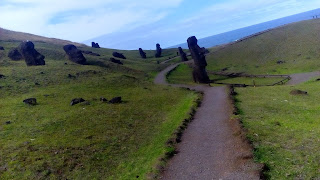
Shortly after going through the admission control, where a park ranger stamps the entry ticket into Rapa Nui National Park, visitors continue to climb Rano Raraku slope by a short trail, which forks ahead. The left path leads to the crater of the volcano and the path to the right goes towards the quarry, where the moai were carved with basalt chisels. This trail is split into several other smaller ones and goes among dozens of those stone beings, all unfinished. Some are standing, others are inclined or even lying down. Many have just the head on display. Mysteriously the works of sculpture and transportation of these moai seem to have been suddenly paralyzed and to be still waiting to be finished.

Trail among unfinished moai

If the moai were carved on the steep slopes of this volcano, weighed at least 5 tons and most of them were more than 4 meters high, how the hell could the Rapa Nui carry all their more than 900 copies to several places of the Easter Island? Considered the greatest mystery of the most isolated inhabited island in the world, there are several theories for this. Unlikely versions claim that the moai came to life and walked by themselves or were transported with the help of extraterrestrials. A more serious theory says that the Rapa Nui tied ropes at the height of the moai's eyes and dragged them standing, swinging them periodically to their sides to keep them balanced. Another theory says that they were transported over wooden platforms, which would explain why there were almost no trees on the island, as the Rapa Nui would have cut them down to transfer the moai. This would also be the reason why the population of the island would have been radically reduced by the XVI century of the Christian era: the almost absence of trees would have led the island to an environmental collapse that would have provoked wars among the tribes because of the scarce natural resources. Truth or not, it's a great lesson for the humankind, right?

The beautiful Rano Raraku's crater

Returning to the starting trail to follow the path leading to Rano Raraku's crater, the visitor may be a little disappointed if a visit to Rano Kau's has already been paid. After ascending a ladder carved on the slope of the volcano, one arrives to a slight and almost circular depression with a lake full of bushes in its center. Some twisted trees around complete the "too quiet" environment of the place. But for safety, it's forbidden to go down there or even to get near the lake.

In the crater of the Rano Raraku volcano

Another attraction that isn't on the volcano, but which is very close to it, is the Ahu Tongariki. From certain stretches of the trail through Rano Raraku quarry it's possible to have a great view of these fifteen moai lined side by side, along with the entire east coast of Easter Island. This is the largest moai's altar and, because of its large amount of stone beings, it's the one that most impresses the visitor. Many people aren't glad just to photograph it, but also try to touch it, which is prohibited and well supervised by the local park rangers. Others end up meditating or kneeling in front of these fifteen majestic beings.

Ahu Tongariki: moai's army showing up

There are several ways to get to Rano Raraku. Loose-budget visitors can rent cars or motorbikes to tour the Easter Island or hire excursions that visit the main attractions of the island and cost about CLP$ 25,000. Whereas low-cost travelers can rent bikes and go cycling a lot, ask for a ride to the friendly Rapa Nui, who don't miss a chance to interact with visitors, or even walk exhaustively under the Polynesian sun enjoying the infinite blue of the Pacific on the east coast of the island. Everything is worth not to miss the incredible place of origin of the enigmatic moai.

East coast of the Easter Island seen from the quarry of the Rano Raraku volcano

domingo, 1 de outubro de 2017


domingo, 1 de outubro de 2017

VOLCANO CRATER ON THE EASTER ISLAND HAS EASY ACCESS TO HIKERS AND DRIVERS


#partiuPartida #ranokau #rapanuinationalpark #easterisland #chile #oceania

Text, Videos and Photos: Ronian Carvalho


Crater of the Rano Kau volcano


Officially a two-hour walk away from Hanga Roa, the only village on Easter Island, the crater of the inactive Rano Kau volcano is one of the most easily accessible in the world. In addition to providing beautiful views of the entire island, the crater is located next to the ruins of the ceremonial village of Orongo, one of the most important places for the Rapa Nui people.

Policarpo Toro street

In Hanga Roa just take the Policarpo Toro street (which lies between the west coast and the beginning of the airport runway) until the point where it turns left and it becomes Camino a Rano Kau. From there, drives must always follow the road up the slope of the volcano and reach the crater in a few minutes. Hikers will see, on the same road bend, a sign on the right that indicates the sendero a Rano Kau, a shortcut to the crater amidst the vegetation.

Sea view from the cave next to the beginning of the sendero a Rano Kau

But, before going up to the volcano, it's worth walking a little to the right towards the sea to get to know one of the caves of the island. A fairly slippery stairway carved through the rocks leads to a cozy opening on the coastal cliff. There you can see spots on the inner rock that, combined with some notches, make visitors imagine different shapes. It's a good place to reflect on life while observing the infinite Pacific Ocean and feeling the rocky embrace of the island. But you have to be careful, because apparently part of the cave is underwater at high tide.

Sendero a Rano Kau, so African-savannah

Back to the climb to the crater of the Rano Kau, anyone who takes the trail passes through different stretches of vegetation. The first of them is a not very dense forest where there are trees of several types and sizes that give a semitropical air to that part of the island. As it's an area with some farms, it's necessary to pass among some fences. But the route is official according to tourism organizations and is well defined, being difficult to get lost there.

View from the end of the sendero a Rano Kau

After the forest there is a long stretch of grasses with a few twisted trees, which give an African-savannah look to the place. Along the way there are two resting places with benches under the slim shadows of these trees. After walking for a few minutes you can look back and see the entire village of Hanga Roa and nearly the full extent of the west coast of the island.

The windy crater of the Rano Kau volcano

The trail ends when it reaches the road of the Camino a Rano Kau. Just cross it and you're already at the viewpoint of the crater. Even those who already know the volcano by photo get impressed by the grandeur of the place. With about 1.5 km in diameter, this huge hole seems to be about to fall into the infinite blue of the sea at its side. A yellow-and-green-grass-patches-covered lake occupies the crater and gives it a look that some people, forcing their imaginations, call it "a world map". The slopes down to the lake are quite steep and are also covered with green and yellow grasses, and by a cluster of pink flowers at a certain point. A trail surrounds the entire crater rim on land and from some of its points it's possible to catch incredible views of the whole island. The wind is very strong at the crater so it's important to be careful for it not to carry cameras, cell phones and personal items away into the crater or into the sea.

West, east and south coasts of Easter Island seen from the rim of the crater of the Rano Kau volcano

When you get tired of being breathtaken at the grandeur of the Rano Kau, it's time to meet the ceremonial village of Orongo, which lies on the southwestern edge of the crater, about 300 meters above sea level. The village was built by the Rapa Nui people for the tangata manu ritual, in which their leaders were crowned. Challenging for any modern athlete, the bird-man ritual consisted of going down the rocky slopes of the island, throwing oneself into the sea, swimming about 3 km to Motu Nui Island, catching an egg of the manutara bird (similar to a seagull), which nests there, and going back to Orongo with it intact. The first to do it all was crowned ruler of the Rapa Nui people. Apparently from religious origin, many aspects of the ritual remain unknown.

Man-bird Island (Motu Nui)

Currently there are only caves and ruins in Orongo, some of them with petroglyphs that give an even greater air of mystery to the place. However, in past there were several buildings with stone walls and thatched roofs where the Rapa Nui priests awaited the return of aspirants to rulers. In addition to the crater of the nearby Rano Kau, Motu Nui's view is impressive too. Whoever hears the story of the tangata manu ritual and sees that little piece of land in the vastness of the Pacific, immediately begins to wonder how much bravery was needed to climb the two islands twice, swim in the rough sea, and still look for a bird's egg.

Orongo's Petroglyphs

Visitors are allowed to enter Orongo only once. The control is made by showing the entry ticket to the Rapa Nui National Park, purchased when landing at Mataveri Airport (in July 2017 it cost US$80 for foreigners). Just after having stamped it at the reception center of Orongo, the visitor can read the panels and informative maps of the small museum there and then get to know the ruins of the ceremonial village through the self-guided path of Orongo. Park rangers, many of them native, are always vigilant so that no smart visitors try to damage, take any historical vestige out of the place or do something dangerous. At the exit you can buy souvenirs about Orongo directly from the hands of some of the Rapa Nui artisans that are next to the parking lot. All in all, it's a tour for different tourist styles, from backpackers looking for stories and adventures, to classical tourists in floral t-shirts and carrying cameras on the shoulders.

Orongo: trails, grasses and ruins

sábado, 23 de setembro de 2017


sábado, 23 de setembro de 2017

THE MOST ISOLATED INHABITED ISLAND OF THE WORLD HAS VOLCANOES, BEACHES, CAVES, ARCHAEOLOGICAL SITES AND MUSEUM

#partiuPartida #easterisland #chile #oceania

Text, Video and Photos: Ronian Carvalho


Distances from the Easter Island (in some unit of measure enough to show that it is far away from everywhere)

About 4,000 km away from any other human civilization, the Easter Island holds the title of the most isolated inhabited place in the world. There's no lack of attractions for those interested in nature, geology, culture or for those who simply want to relax. Despite being under Chilean administration, the island has almost nothing to do with South America.
Tropical trees swaying in the wind, tourists with flower necklaces, natives with Polynesian traits speaking the rapa nui language (or Spanish with strong foreign accent), and, above all, the various moais scattered everywhere are the registered trademark of the Easter Island. Whoever comes from Santiago de Chile and arrives at Aeropuerto Mataveri, built by NASA in 1985, already has the impression of being in Oceania.


Landing at Mataveri International Airport. You can see a bit of the slope of the Rano Kao volcano

Formed by the constant eruptions of three large volcanoes over the centuries (Rano Rarako, Rano Kao and Poike), the Easter Island features an almost triangular territory of roughly 150 square meters of mostly volcanic soil. Even so, there are two sandy beaches on the Island: Anakena and Ovahe. Although its sea water is reasonably cold at certain times of the year and the local weather is rather unstable, relaxing a little on one of these beaches, either by lapping on the sand or bathing in the clear Polynesian Sea, under the watchful eye of the mysterious moais, is a unique and fantastic experience.

One of the many moais on the Easter Island. This one has eyes made of shells.

Speaking of moais, these stone figures, carved on the slopes of Rano Rarako volcano, are the main icon of the Easter Island. Made to represent Rapa Nui tribes' ancestors, almost all of them were positioned with their backs to the sea, as if they were photographs hanging on a wall. Many have been placed on pedestals, called ahus, and some have special features such as hat and eyes made of shells. The Sebastián Engler Museum, located in Hanga Roa, the only village on the island, has a vast collection that details very well the process of construction and the meanings of these stone beings for the Rapa Nui people, besides presenting various natural and human aspects of the Easter Island. Admission is free.

Trail on the slope of the Rano Kao volcano

Being a volcanic island, these elevations with craters couldn't miss. At least two of the island's volcanoes can be known by hiking, Rano Rarako and Rano Kao. The ways there involve roads, forests, green plains, steep slopes and incredible views throughout the course. There are also trails that lead to archaeological sites and caves, where the natives used to hide from invading peoples.
Interested in learning more about the Easter Island? Wait for the next posts ...